

TRUSTED FOR HOMES, EXTENSIONS, REFURBISHMENTS AND COMMERCIAL PROJECTS ACROSS ENGLAND DELIVERED WITH PRECISION, CLARITY AND CONSISTENCY

A MEASURED SURVEY IS ONLY AS GOOD AS THE DRAWINGS YOU RECEIVE.
At Space Captures, we deliver accurate, clean and dependable as-built information that design teams can use immediately — with no guesswork, no re-drafting, and no hidden surprises onsite.
This is modern building documentation: fast, reliable and ready for design.
WHAT’S INCLUDED IN EVERY MEASURED BUILDING SURVEY
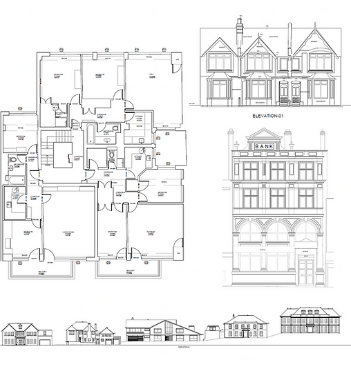
Every measured building survey is delivered as a coordinated documentation package, structured for design and planning workflows.
Delivered clearly and consistently as DWG + PDF
-
Full internal laser scan
-
External elevations captured in detail
-
Floor plans (all levels)
-
Elevations (front, rear, sides)
-
2–4 cross sections
-
Roof plan
-
Basic site plan
Optional Add-Ons:
-
Topographic survey (front/rear gardens) - BIM / Revit model - Additional sections - Outbuildings - Boundary checks
WHY HOMEOWNERS, ARCHITECTS AND DEVELOPERS CHOOSE US
Drawings Architects Trust
Clear Scope, No Surprises
Responsive Scheduling
Predictable Delivery
Straightforward Process
RECENT PROJECTS


HOW IT WORKS
01
Send your address and requirements
02
Receive same-day quote
03
Survey completed at your property
04
Drawings delivered in 5–7 working days
FREQUENTLY ASKED QUESTIONS

WANT A QUOTE RIGHT NOW?

We typically reply with a personalised quote same day.
If you’re unsure whether this is the right service, send us a brief message — we’ll let you know quickly and honestly.